
 Sedona has trails all around it, in fact you can almost ride around the whole city on trails except for a few places that are wilderness and they don't allow bikes. The trails are well maintained and well marked in most cases. The trails have a wide variety of difficulty level. In some places it will be smooth and easy going but in many cases there are some difficult and technical sections. Most of the technical sections are short and if it is beyond your skill you can just walk that part and be back on your bike riding primo trails again in no time. The Sedona trail system has in my view four main parts. They are the south, north, central, and the west areas. There are some areas not included in these four main parts, but for ease of discussion I will exclude them. My favorite is the south area followed by the north area, but it is all good. In this post I will talk about the north and south parts and deal with the others at another time. I have pieced together a few maps to help out. They were partial areas and had some inaccurate info so I tried my best to improve them.
The Templeton Trail branches off the pathway just north of what is called "Baby Bell" (a small rock butte just north of the much larger Bell Rock) and heads west and then goes under the highway and then takes you to Cathedral Rock.
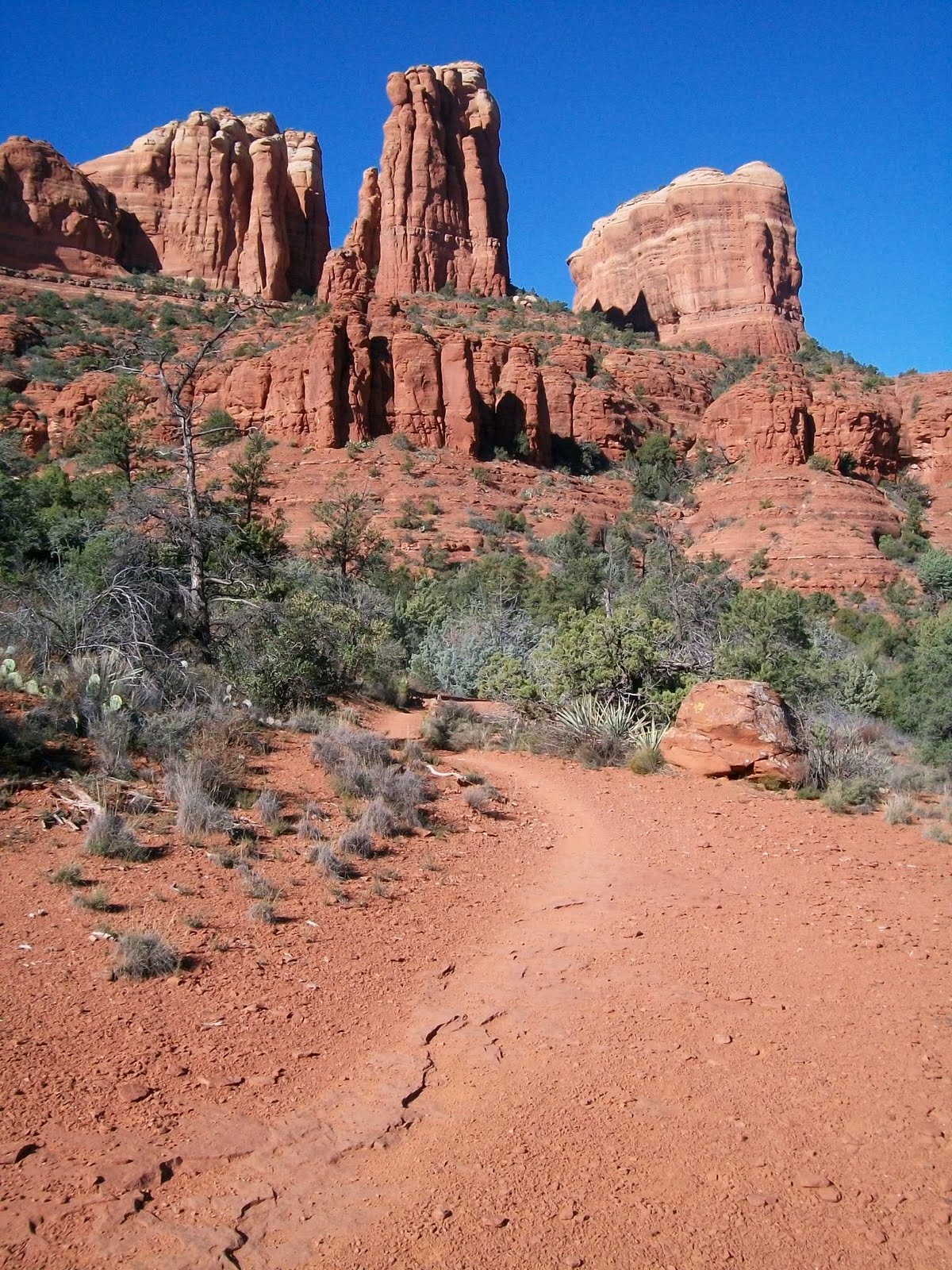 The trail skirts along the north flank of this ridge that contains Cathedral Rock and then leads you to Oak Creek then goes south along the creek and eventually to world famous Red Rock Crossing. I love this trail for it's scenery and I love a part that travels for a time on a nice rock ledge contouring to the terrain around the base of Cathedral Rock. It is very cool.
  Along the way you pass the Cathedral Rock Trail coming up from the Cathedral Rock trail head and heading up to the saddle of Cathedral Rock. Once at Red Rock Crossing you can cross the creek and head into the central part of the trail system that takes you to what is called West Sedona or you can complete a loop around Cathedral Rock by taking Verde Valley School Road back into the Village Of Oak Creek and Highway 179. Or you can go south into Redrock State Park and to more trails.
The HT trail branches west off the Redrock Pathway near the north end of the pathway. It too goes under the highway and then connects to the Templeton Trail and helps make loop rides happen that can include parts of Templeton Trail. There is also a trail that heads south from the intersection of HT trail and Templeton Trail that is somewhat new that goes all the way to The Village Of Oak Creek on the west side of the highway. This new trail is very cool and helps make for some new longer loop ride opportunities. This photo is taken from that trail west of the highway and Bell Rock, looking out to the northeast toward Elephant Rock and the Twin Buttes
 Branching off to the east side of the Redrock pathway is the Llama trail. This trail branches off to the east just north of Courthouse Butte. There is a major intersection on the pathway where a trail that circles Courthouse Butte heads east. You take this and after a short way the Llama Trail splits off to the left heading northeast. You cannot take a bike on the Courthouse Trail around the Butte because it is in a wilderness area so you must turn off at the Llama Trail before the Wilderness boundary. Llama Trail was started by a guy that did Llama tours years ago and then was found by mountain bikers. The Forest Service did not really maintain it or recognise it as an official trail for quite a long time. When I first started riding it 13 years ago it was little used and narrow. Now it is quite well traveled and wider like most Sedona trails. This photo is a typical view along the Llama trail looking east to what I guess would be Lee Mountain in the Munds Mountain Wilderness.
  The Llama trail skirts along the west border of the Munds Mountain Wilderness heading north and eventually intersects the Little Horse Trail .
The Little Horse trail branches east off of the Redrock Pathway near it's north end and heads up to a pass between some large mountains called Chicken Point. It travels just south of two large and impressive spires of rock called the Twin Buttes (also called two sisters).
 The trail leads you up to a pass between the mountains called Chicken Point. Chicken Point is a large area of flat slickrock at the north east base of the Twin Buttes with a steep drop off on the south side. This has great views off to the south and west and the jeep tours take people out here. This is what it looks like just east of Chicken point looking west at the east side of the Twin Buttes.
 This old dude on an old classic Ibis bike is me AZ Jones on the slick rock at Chicken Point.
 At this point there is a trail at the west end of the slick rock area that heads north along the base of the mountain called Elephant Rock. You just follow the rock stack markers. Don't take the jeep roads.
  This trail is called Broken Arrow Trail. Broken Arrow Trail has great views across an unpopulated valley to Munds Mountain and the Devils Dining Room. The Broken Arrow Trail takes you north to the Broken Arrow trail head at the end of Morgan Road. There is a short side trail that leads down into the valley to a large exposed rock area called Submarine Rock that is fun to freelance all over.
 This trail to the saddle and down the other side is called Hangover Trail. It can be difficult to follow and has some very difficult and technical sections that should be tried by advanced riders only. There is some serious exposure in some spots on this trail.
The other half of the North area of Sedona trails is west of Oak Creek. This part has a trail called the Thompson Trail that starts at Migley Bridge heads north and then southwest along the base of Steamboat Rock. Steamboat rock is a prominant rock formation at the base of the large mass of Wilson Mountain. This photo is of Wilson mountain as seen looking northeast from the Jordan Trail.
 The Thompson Trail follows an old wagon route that Jim Thompson an early homesteader used to take supplies up into Oak Creek Canyon. The Thompson trail goes from Migley Bridge at one end to the Brins Mesa Trail Head Just Northwest of the older or uptown part of Sedona. You cannot take the Brins Mesa Trail (that heads north) because it heads into wilderness areas where bikes are not allowed. Instead you continue from there west on The Jordan Trail into an area that the locals call the Secret Trails. The Jordan Trail will take you over the Soldiers Pass Trail Head and Coffee Pot Rock. This is a typical scene olong the Jordan Trail looking west toward Coffee Pot Rock.
 The Secret Trails area has several side trails and many wind up in the bottom of a wash and into a maze of bootleg trails that can be confusing. This is a photo looking north from the Secret Trails area.
  Once over at the Soldiers Pass Trail head there is another trail that heads west called the Tea Cup Trail that takes you out west at the base of Coffee Pot Rock and up to Sugarloaf and the Little Elf Trail Head. From here you can continue west out past Chimney Rock and Lizard Head Rock and out to the western area of trails that I will cover in another post.
AZ Thanks for sharing! This puts me in the mood for an outing, however here it is in the 20's and so it will be briefer and I'll be well jacketed.
ReplyDeleteBlessings to you and yours this Thanksgiving day!
Chuck
Where is here, for you Chuck? Sounds like it is time for a road trip.
ReplyDeleteOn the edge of nowhere in Idaho. Road trip will have to wait til spring. Dylan came within driving distance this summer , so who can complain :}
ReplyDeleteWell Chuck. There are good sides and downsides to everything. Idaho has great winter sports, solitude, no traffic, nice summers and much more. Sounds good to me.
ReplyDeleteAZ Jones! Thank you so much for this site. I live in Ottawa, Canada and am planning a dream mountain biking vacation to Arizona at the end of January. It has always been my dream to mountain bike and experience Arizona and Utah. Although I may not have enough time to get to Utah, I am soooo excited for all of the great outdoor adventures that await me in and around sedona. Things aren't going too well with the misses and I'm really looking forward to this trip to find myself.
ReplyDeleteThanks so much for your site. It's helping me so much in my trip planning.
If you had to list out a top 5 must see places what would they be? Minus the grand canyon of course as I already have that on the list. ; )
-Kevin
Well Kevin. It all depends on time of year. You can't mountain bike the Rainbow Rim of the Grand Canyon in winter. And you can't Moutain bike the Mt. Eldon Trail system near Flagstaff in winter. South Mountain in Phoenix is a Good desert Mt. Bike destination for winter as is several locations in Tucson AZ. When it is dry Sedona is still OK in winter. Sorry to hear there is problems in your relationship. Maybe you should stay home and work on that. After all relationships are of top priority in life. Hope you can show unconditional love even when not respected. God bless. AZ Jones
ReplyDeleteAmazing collections.Nice topic.I like it.Thanks for sharing.
ReplyDeleteseo europe