I live 20 minutes from
Sedona and I have mountain biked there many, many times. I have been riding there frequently since the late 90s. I went there just last weekend and the weather was a perfect 72 degrees. The trails in
Sedona are very nice and the scenery is amazing, I'm talking truly amazing. So I decided to share some information about this great place to mountain bike.
 Sedona
 has trails all around it, in fact you can almost ride around the whole city on trails except for a few places that are wilderness and they don't allow bikes. The trails are well maintained and well marked in most cases. The trails have a wide variety of difficulty level. In some places it will be smooth and easy going but in many cases there are some difficult and technical sections. Most of the technical sections are short and if it is beyond your skill you can just walk that part and be back on your bike riding
primo trails again in no time. The
Sedona trail system has in my view four main parts. They are the south, north, central, and the west areas. There are some areas not included in these four main parts, but for ease of discussion I will exclude them. My favorite is the south area followed by the north area, but it is all good. In this post I will talk about the north and south parts and deal with the others at another time. I have
pieced together a few maps to help out. They were partial areas and had some
inaccurate info so I tried my best to improve them.
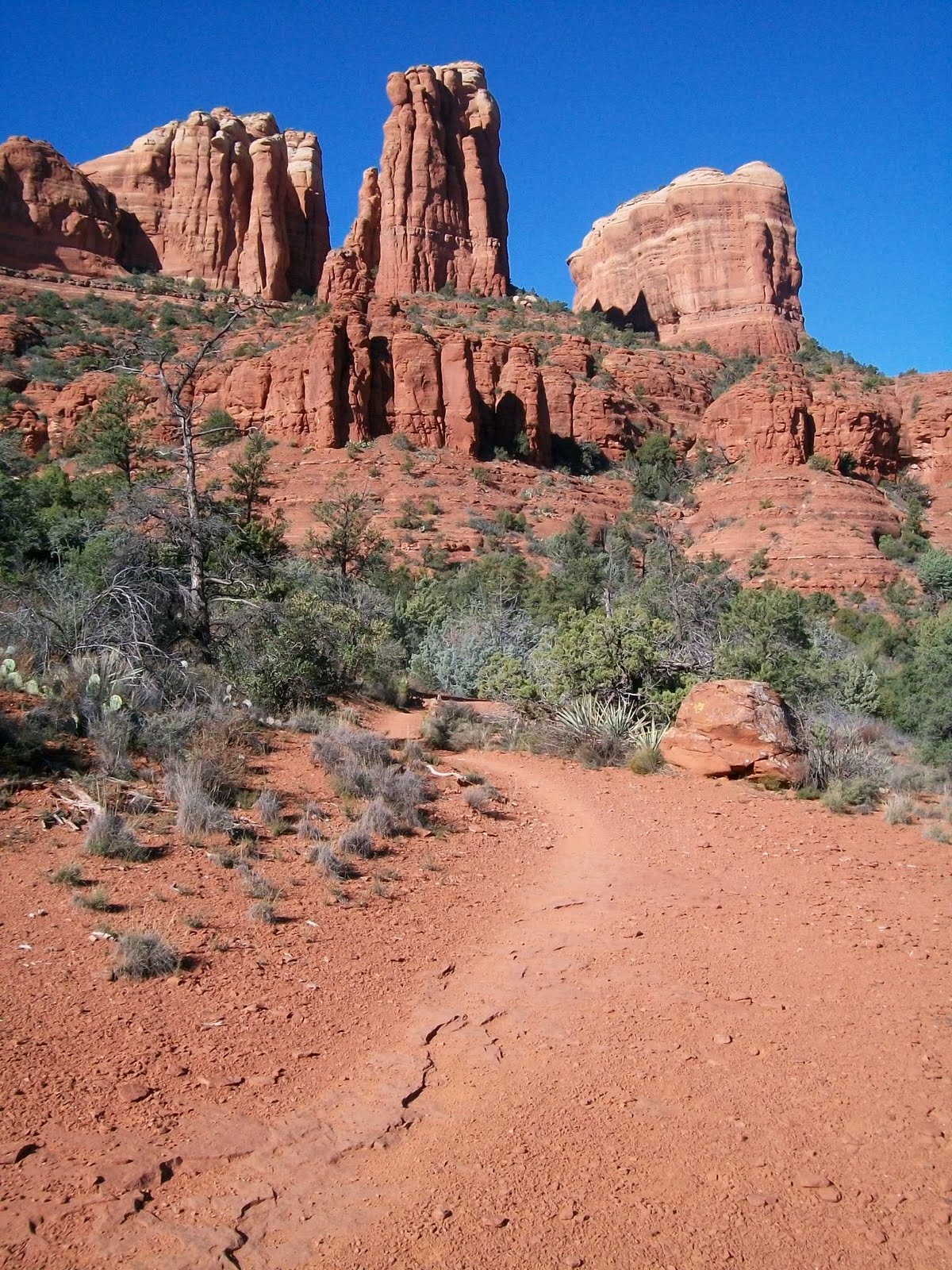
The south part is from
Munds Mountain Wilderness on the east side to Oak Creek and from Morgan road and Broken Arrow trail head in the north south to the Village of Oak Creek. This area of trails divided in two by highway 179. There are two places where you can go under the highway bridges or in a tunnel that connect the areas. Running north and south through this area parallel to the highway is the
Redrock Pathway, and many of the trails branch off from it. The
Redrock Pathway is a wide foot and bike path that starts at the Courthouse Butte parking area and goes north terminating at the Little Horse Trail Head parking area. The
Redrock Pathway is reasonably smooth (by
Sedona standards) and is wide so people traveling in both directions can pass with ease. It is a good place for beginners to try mountain biking for a first time. No technical skill needed at all. The main trails that branch off the
Redrock Pathway are the Llama Trail and the Little Horse Trail on the East side and the Templeton Trail and the HT trail on the west side.
The Templeton Trail branches off the pathway just north of what is called "Baby Bell" (a small rock butte just north of the much larger Bell Rock) and heads west and then goes under the highway and then takes you to Cathedral Rock.

The trail skirts along the north flank of this ridge that contains Cathedral Rock and then leads you to Oak Creek then goes south along the creek and eventually to world famous Red Rock Crossing. I love this trail for it's scenery and I love a part that travels for a time on a nice rock ledge contouring to the terrain around the base of Cathedral Rock. It is very cool.

Along the way you pass the Cathedral Rock Trail coming up from the Cathedral Rock trail head and heading up to the saddle of Cathedral Rock. Once at Red Rock Crossing you can cross the creek and head into the central part of the trail system that takes you to what is called West
Sedona or you can complete a loop around Cathedral Rock by taking Verde Valley School Road back into the Village Of Oak Creek and Highway 179. Or you can go south into
Redrock State Park and to more trails.
The HT trail branches west off the
Redrock Pathway near the north end of the pathway. It too goes under the highway and then connects to the Templeton Trail and helps make loop rides happen that can include parts of Templeton Trail. There is also a trail that heads south from the intersection of HT trail and Templeton Trail that is somewhat new that goes all the way to The Village Of Oak Creek on the west side of the highway. This new trail is very cool and helps make for some new longer loop ride opportunities. This photo is taken from that trail west of the highway and Bell Rock, looking out to the northeast toward Elephant Rock and the Twin Buttes

Branching off to the east side of the
Redrock pathway is the Llama trail. This trail branches off to the east just north of Courthouse Butte. There is a major intersection on the pathway where a trail that circles Courthouse Butte heads east. You take this and after a short way the Llama Trail splits off to the left heading northeast. You cannot take a bike on the Courthouse Trail around the Butte because it is in a wilderness area so you must turn off at the Llama Trail before the Wilderness boundary. Llama Trail was started by a guy that did Llama tours years ago and then was found by mountain bikers. The Forest Service did not really maintain it or recognise it as an official trail for quite a long time. When I first started riding it 13 years ago it was little used and narrow. Now it is quite well traveled and wider like most
Sedona trails. This photo is a typical view along the Llama trail looking east to what I guess would be Lee Mountain in the
Munds Mountain Wilderness.

The Llama trail skirts along the west border of the
Munds Mountain Wilderness heading north and eventually intersects the Little Horse Trail .
The Little Horse trail branches east off of the
Redrock Pathway near it's north end and heads up to a pass between some large mountains called Chicken Point. It travels just south of two large and impressive spires of rock called the Twin Buttes (also called two sisters).

The trail leads you up to a pass between the mountains called Chicken Point. Chicken Point is a large area of flat
slickrock at the north east base of the Twin Buttes with a steep drop off on the south side. This has great views off to the south and west and the jeep tours take people out here. This is what it looks like just east of Chicken point looking west at the east side of the Twin Buttes.

This old dude on an old classic Ibis bike is me AZ Jones on the slick rock at Chicken Point.

At this point there is a trail at the west end of the slick rock area that heads north along the base of the mountain called Elephant Rock. You just follow the rock stack markers. Don't take the jeep roads.

This trail is called Broken Arrow Trail. Broken Arrow Trail has great views across an unpopulated valley to
Munds Mountain and the Devils Dining Room. The Broken Arrow Trail takes you north to the Broken Arrow trail head at the end of Morgan Road. There is a short side trail that leads down into the valley to a large exposed rock area called Submarine Rock that is fun to freelance all over.
The north area of trails in
Sedona is divided into two parts by Oak Creek. East of the creek are the
Huckaby Trail that That goes from
Schnebly Hill road parking area down to the creek under
Migley Bridge and the majority of it is downhill. But once at the creek there is a steep climb up out of the canyon to get the the road and parking area at
Migley Bridge. East of the
Schnebly Hill parking area is the
Munds Wagon Trail. This trail runs parallel to
Schnebley Hill Road and ends up at an area called The Carousel. This is uphill most of the way with a few crossings of a wash and a few crossings of the road. You could have someone drop you off at the top and ride downhill and continue on
Huckaby all the way to the Oak Creek. It would be a fun downhill run. Part way up the
Munds Wagon Trail is a side trail to the north that leads out to some large flat areas of rock called the Cow Pies. This is a fun place to just goof around. like a giant skate board park for bikes but with world class views. At the north most of the Cow Pies there is a trail that heads west along a ledge in the rocks out to a saddle and then drops over the saddle and down to Oak Creek and comes out at Grasshopper Point in the canyon. This photo is taken from the Cow Pies looking at the saddle.

This trail to the saddle and down the other side is called Hangover Trail. It can be difficult to follow and has some very difficult and technical sections that should be tried by advanced riders only. There is some serious exposure in some spots on this trail.
The other half of the North area of Sedona trails is west of Oak Creek. This part has a trail called the Thompson Trail that starts at Migley Bridge heads north and then southwest along the base of Steamboat Rock. Steamboat rock is a prominant rock formation at the base of the large mass of Wilson Mountain. This photo is of Wilson mountain as seen looking northeast from the Jordan Trail.

The Thompson Trail follows an old wagon route that Jim Thompson an early homesteader used to take supplies up into Oak Creek Canyon. The Thompson trail goes from Migley Bridge at one end to the Brins Mesa Trail Head Just Northwest of the older or uptown part of Sedona. You cannot take the Brins Mesa Trail (that heads north) because it heads into wilderness areas where bikes are not allowed. Instead you continue from there west on The Jordan Trail into an area that the locals call the Secret Trails. The Jordan Trail will take you over the Soldiers Pass Trail Head and Coffee Pot Rock. This is a typical scene olong the Jordan Trail looking west toward Coffee Pot Rock.

The Secret Trails area has several side trails and many wind up in the bottom of a wash and into a maze of bootleg trails that can be confusing. This is a photo looking north from the Secret Trails area.

Once over at the Soldiers Pass Trail head there is another trail that heads west called the Tea Cup Trail that takes you out west at the base of Coffee Pot Rock and up to
Sugarloaf and the Little Elf Trail Head. From here you can continue west out past Chimney Rock and Lizard Head Rock and out to the western area of trails that I will cover in another post.

 Here is another great Eastern Sierra backpack trip. This one starts at a large lake called Lake Sabrina at 9132 foot elevation. I like this trip because the starting point is so high that there is not very much climbing to get to the good stuff. This trip heads into a lake basin called The Sabrina Basin in the John Muir Wilderness of the Inyo National Forest in California.
 About 1.3 miles from the road there is a trail junction with an east bound trail that leads to George Lake up on Table Mountain. You continue right or south at this junction. You will soon pass the small outlet creek for George Lake and then the trail starts to climb some switch backs. After the switch backs you arrive at Blue Lake at around 10400 foot elevation. This lake is beautiful and if this were the only lake on the trip it would still be worth the short trip.
  There are great views south across the lake of some dramatic peaks along the Sierra Crest, with a prominent pointed bare spire in the foreground that is close to 12,500 feet tall and Thompson Ridge with Mount Thompson at over 13,400 foot height behind in the back ground. This lake is only a little over 2.5 miles from the road so many day hikers can make this their destination.
 The trail then crosses the outlet creek of Blue Lake and then heads along the west shore of the lake. After a short way you come to a trail junction. If you head straight it will take you to Donkey Lake and the Baboon Lakes, a worth while side trip if you have the time. I did this on the way back.
  This is what it looks like up there at one of the lakes. And there is a lot of great stuff to explore using these lakes as a base camp you could go up to Sunset Lake and get a view of the Thompsom Glacier. But our trip takes the right fork and heads west at this junction. After about a mile and a quarter from this trail junction you will get to the largest of the Emerald Lakes about four miles from the road. You pass this lake and continue southwest up over a small rise to Dingleberry Lake at about 10490 foot elevation. You pass this lake along it's east shore and continue up the drainage. Less than a half mile past Dingleberry Lake and about five miles from the road there is a trail junction. If you head south or take the right fork it will take you to beautiful and dramatic Midnight Lake. Midnight Lake is at close to 11,000 foot elevation and is in a bowl surrounded by steep rocky cliffs and ridges and dramatic peaks.
 I camped here and loved the beautiful play of light off the peaks. I believe that the tall peak reflected in this photo is Mount Darwin at 13,831 feet tall.
  If you take the left fork of the trail junction below Midnight Lake it takes you to Topsy Turvy Lake where there are some great campsites with fantastic views. If you continue on past Topsey Turvy Lake you will soon reach Hungry Packer Lake at 11,070 foot elevation about 6.3 miles from the road. This lake has a dramatic spire called Picture Peak rising up just south of it making for a beautiful scene.
  From here it is a short walk west over to Moonlight Lake were the views across the lake to the Jagged Sierra Crest are fantastic.
  These photos were taken at the outlet of Moonlight Lake and fit together as a panorama. The prominent Peak in the fore ground is Picture Peak with Mount Hackel in the right background and Mount Powell and the Clyde Spires to the Left.
  Here is a pieced together panorama of the view from this same location as is the one at the start of the post.
  From here you can continue up the valley to the source of the Middle Fork of Bishop Creek to Echo Lake. If you are really a veteran and experienced back country traveler you could cross the Sierra Crest via this trail less route over Echo Pass and end up in Kings Canyon National Park in the Evolution region. Me I just enjoyed the short walks between the fantastic lakes in this basin and then headed back the way I came.
 By the way all these lakes have abundant trout if that's your thing. Like all Eastern Sierra trips in wilderness areas permits are required, so plan in advance.


