..........................................................Arizona Jones Outdoors: Hiking, Backpacking, Mountain Biking, and more!

Tuesday, June 28, 2011

Slide Rock State Park, Arizona, Part Two

In the summer in Arizona we are always trying to find a way to cool off. And that often includes taking a swim in one of the many creeks that come down from the rim country. One of the most visited spots is Slide Rock State Park. I already did a post on this but with temperatures at 107 this week in Cottonwood and over 115 in Phoenix I decided to go back to cool off and here are some more photos of that special spot. 

The thing that makes Slide rock special is not just the water but the many different ways to enjoy it. Of course there are the water slides.
And then even more water slides!
But along with that are the many deep pools where you can jump off rocks.
And if that is not enough and you want some some bigger thrills, you can jump off some pretty tall cliffs into some real deep pools that are under the highway bridge!
Here is one of the brave ones hucking his body off the ledge into the water below.
But for me I like taking a walk up stream away from the crowds to the more secluded spots.  This next photo is looking back downstream as you leave the people behind. 
Upstream you will find some beautiful locations, where it is more quiet, and has a more wild feel. 
Here there are some nice pools and some places where the cliffs close in on the creek reminiscent of Clear Creek but much easier access. 
This is why so many people flock to Slide Rock and Oak Creek Canyon every summer, and why they come back year after year.
Now Slide Rock State Park is $20 per car to enter, but you can park upstream and hike down. There is a "redrock" pass required to park anywhere in the canyon however. There are some other great spots in the canyon where you can enjoy the creek this is just the one with the most to offer.
Here is the link to Slide Rock State Park, Part One, in case you missed it.

Tuesday, June 21, 2011

Mountain Biking Mount Elden, Flagstaff AZ

   Well anyone that knows me, "Arizona Jones", knows that I like to mountain bike.  In the summer it can get pretty hot in Cottonwood where I live.  In fact temperatures of well over 100 degrees are nothing unusual.  So when it gets hot I like to travel to higher elevation where it is cooler to ride.  One of those spots is Mount Elden near Flagstaff Arizona.  Mount Elden is part of a series of mountains north of Flagstaff called the San Francisco Peaks volcanic field.
 Mount Elden is one of the  peripheral mountains and it rises up above the already 7000 foot high plateau that Flagstaff is on.  Mount Elden is one of the farthest south of these mountains and is also one of the smaller ones being about 9297 feet in elevation.  Some of the other peaks reach as high as 12,000 feet. 
   Most of the other mountains are in a designated wilderness area but Mount Elden is not and so Mountain Bikes are allowed.  On Mount Elden is a great trail system that gives you opportunity for many different loop or out and back options.  With the bottom of the mountain being a full 2000 feet below the summit there are also great opportunities to get in some fun downhill runs as well as the tough climbs for those who want a serious workout.  And serious climbs at this altitude will really test even the best mountain bike riders. 
  
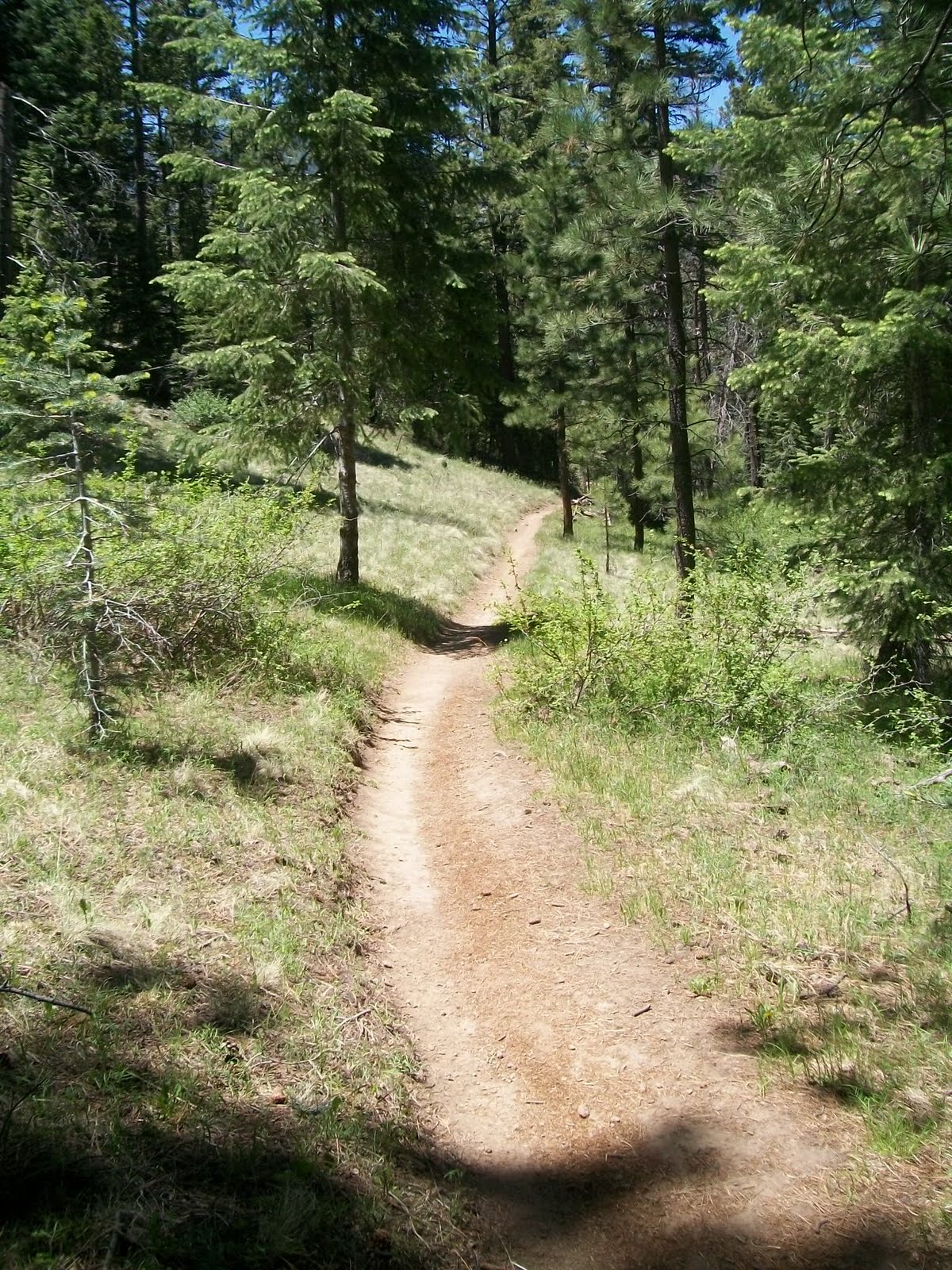
But for me it is about not just the workout but the enjoyment and the beauty.  Mount Elden is covered with a beautiful forest with a variety of trees including Ponderosa Pine, Douglas Fir, and Aspens. The eastern slopes of Elden were badly burnt by the Schultz Fire in June of 2010 but much of the good stuff is still intact. So here are some trail descriptions, to help plan a ride or hike.
Oldham Trail #1
Mt. Elden's longest trail at 5.5 miles, it begins at the north end of Buffalo Park (elev. 7,000 feet) in Flagstaff and climbs gradually past boulder fields and cliffs on the west side of Mt. Elden. You cross Elden Lookout Road several times as the trail winds higher through forest and meadows to Oldham Park and on to Sunset Trail near the summit. The trail is moderate at the bottom but gets very difficult on the upper part if you are climbing and has an elevation gain of 2,000 feet.
Rocky Ridge Trail #153
Ponderosa pine, Gambel oak, alligator juniper, cliffrose, and yucca line this western approach to Mt. Elden. This trail begins from Schultz Creek Trailhead heads east and connects with the Oldham and Brookbank Trails. Distance is 2.2 or 3 miles depending on which fork you take. Schultz Creek Trailhead lies a short way off Schultz Pass Road 0.8 mile in from US 180. Elevation change is only about 100 feet but there are some rocky technical parts on this trail.
Brookbank Trail #2
This moderate to steep 2.5-mile trail climbs north through a forested drainage to the edge of Brookbank Meadow, owned by the Navajo Tribe, then curves east to eventually meet Sunset Trail at a low saddle. The part of the trail between Brookbank Meadow and the Sunset Trail goes through some very nice forests and meadows.  Elevation gain is 1,000 feet. The trailhead (elev. 7,900 feet) can be reached by hiking or biking the Rocky Ridge or Oldham Trails or by driving a half mile in on Schultz Pass Road from US 180, then turning 2.5 miles up Elden Lookout Road.
When at Brookbank Meadows in the Dry Lake Hills area I often take an unnamed trail out southwest across the meadows to a view point that over looks parts of Flagstaff. There is a rock outcrop that I often take a break at and enjoy the view.
Schultz Creek Trail #152
This gentle 3.5-mile trail parallels an intermittent creek and also paralles Schultz Pass Road. The top is at Shultz Pass at the Sunset Trail Head (elev. 8,000 feet) and the bottom at Schultz Creek Trailhead (elev. 7,200 feet). Sunset Trailhead is at Schultz Pass, 5.6 miles up Schultz Pass Road from US 180, and Schultz Creek Trailhead is a short way off Schultz Pass Road 0.8 mile in from US 180. This is a very fun and fast downhill!
Sunset Trail #23
The alpine meadows and forests on the north side of Mount Elden offer some of the most pleasant hiking and bikling in Arizona. The four-mile Sunset Trail climbs gradually from Schultz Pass through pine, fir, and aspen to Sunset Park and on to the summit; elevation gain is 1,300 feet.  as you climb away from Schultz Pass you have some nice views back towards the San Francisco Peaks.  Latter as your head south you will traverse along the eastern edge of Mount Elden and will see below the visible scars left by the Radio Fire of 1977, and more recently the damage left from the Schultz Fire.  from different points on the Sunset trail you can view the San Francisco Peaks, Sunset Crater, and Painted Desert.
Begin from the Sunset Trailhead (elev. 8,000 feet), just west of Schultz Tank at Schultz Pass. To reach the trailhead, follow US 180 northwest three miles from downtown Flagstaff to Schultz Pass Road, then turn right 5.6 miles.

Little Bear Trail #112
This trail is steep in places with some switchbacks is 3.5 miles long with a 1,000-foot elevation change between Little Elden Trail and Sunset Trail. This may be still closed due to the big Shultz Fire in June of 2010.  This area being burned is a sad loss.  It was a real fun and beautiful trail to ride. 

Little Elden Trail #69
This trail descends down to the east side of Shultz Pass from Schultz Tank and links to trails that wind around the base of Mount Elden. From Schultz Tank to the bottom of Heart Trail in 4.7 miles. I have not tried this area since the Shultz Fire but I'm pretty sure this area has significant damaged.

Here is a trail map I came up with to help navigate.  There are also many trails that are not named that are north of Schultz Pass Road that can be explored.  As well as several on Elden itself. 

My earlier post about the Shultz Fire  http://azjonesoutdoor.blogspot.com/2010/07/fire-on-mountain.html  

Here is the best map I have found for the Mt. Elden trails by Dale Wiggins. It has many on it I have not been on. Very detailed!
http://singletrack.us/gallery/displayimage.php?album=58&pos=0

Thursday, June 16, 2011

Fossil Creek, Part Two

I can't get enough of this place.  Fossil Creek is just so beautiful and the water is so perfect that you just want to keep going back.  So yesterday I had a day off so I took my child and her friend back for another great day in paradise. 
Since I could not get enough I thought maybe you might not of had enough yet as well.  So i took a few more pictures to share of this amazing place. 
This one is at the falls that I posted the other day but from above.  As you can see you can climb around to the top of the falls and many people jump into the deep pool from the cliff 30 or so feet above the water.  The fall is at least 20 feet in height, so I'm guessing the cliff is at least 30 feet or more. 
The stream has great waterfalls but also nice lazy and deep pools to relax in.  There is also some "white water" or rapids type areas.  I guess some people have gone down this river in kayaks, and even gone down the falls. 
Anyway I feel pretty blessed to have this fantastic place within driving distance, so I can take a day trip over there and enjoy the water. 
Oh The Water. . Ooohhh The Water. . And It Stoned Me To My Soul
Here is the link to the other Fossil Creek Post in case you missed it  
http://azjonesoutdoor.blogspot.com/2011/06/fossil-creek-arizona.html
And here are a few maps that might be of value. 


Anyway if you want to go here DON'T. . . . because I want it ALL to myself!  Like that could ever happen. Anyway for more information contact:
Mogollon Rim Ranger District, 8738 Ranger Road, Happy Jack AZ 86024, (928) 477-2255 FAX 527-8282
or
Verde Ranger District, 928-567-4121 or
Red Rock Ranger District, P.O. Box 20249, Sedona AZ 86341, (928) 282-4119

Sunday, June 12, 2011

Fossil Creek, Arizona

When things start to heat up in Central Arizona there is a special place I like to visit to cool off. It is an amazing place just east of Camp Verde called Fossil Creek. Fossil Creek is a spring fed stream that runs southwest from its source for about fifteen miles and empties into the Verde River.
Fossil Creek is fed by a spring that produces close to a million gallons of crystal clear water an hour. This water comes out of the ground at a perfect 72 degrees and is full of minerals that give the creek an amazing aqua blue color. The surrounding area is a high desert environment in an entrenched canyon with mesquite, pinion pine and Juniper, along with some cactus and yucca. The canyon bottom is about 4300 feet in elevation while the canyon rim is above 6000 feet. While the canyon environment is typical of the high desert the environment along the creek is unique and special due to all the water. Along the creek is one of the most diverse riparian areas in Arizona, with over thirty species of trees and shrubs and over a hundred species of birds that have been observed in this unique habitat.
Visiting Fossil Creek is easy because a road runs parallel to it for a few miles and crosses it on a bridge in one location. The great swimming holes and easy access can make some of the spots very crowded. The places right below the bridge while nice are often very crowded.
Farther up the road from the bridge is a trail access that leads to a beautiful waterfall. The trail is only about a mile or so long and winds along the creek and on the way you pass several small falls and pools that are quite spectacular.
The falls at the end of this trail while often crowded are amazing and well worth the short mile hike. The falls are about 20 feet high with a deep pool of crystal clear water.
Many people come here to dive off the rocks and the falls into the deep water below. And it can be very crowded and busy on the week ends.
 If you want more solitude there are several other spots you can stop between the bridge and the falls trails that all have great swimming opportunities that offer more peace and quiet. 
If you want even more solitude there is a three mile long trail that leads to the spring at the source of the creek. This trail starts farther up the road toward strawberry and drops 1300 feet down to the spring. This will tend to have a little less traffic than the easy to reach spots that are close to the car. Hiking up stream past the falls or downstream from the springs will offer you more solitude as well, where you might find that perfect place to have all to yourself.
The Creek was not always this nice. For a long time much of the water flow was diverted by a dam and traveled by flume to a power plant. The work on the dam and power plant started in 1916 and in the 1920 and 30s this helped supply power to Phoenix. The power plant was decommissioned in 1999 and now the full flow of the creek has been restored, and the results are amazing. 
To get to this desert oasis called Fossil Creek you take Interstate 17 north from Phoenix or south from Flagstaff. You exit on State Route 260 heading east and pass through Camp Verde. You then turn right on Forest Road 708 (sign says Fossil Creek) less than 10 miles from I-17. The forest road is very winding and also very bumpy but it's passable by standard vehicles if you take it slow. It is about 15 miles of dirt road to the Fossil Creek Bridge. You can also come down this same road from Strawberry. At Strawberry from Highway 87 you take Fossil Creek Road (Forest Road 708) for about 5 miles to get the Fossil Springs trail head. The first 2 miles or so is paved; the next 3 miles will be on a rough but maintained dirt road that any car can drive on. After about 5 miles on Fossil Creek Road you'll see a turnoff that leads to a parking lot on the right side. If you continue down the main road for a few more miles you will reach the Fossil Creek Bridge. Haven't had enough? Or need more informations? Here is another post for this fantastic Paradise in the desert!
http://azjonesoutdoor.blogspot.com/2011/06/fossil-creek-part-two.html