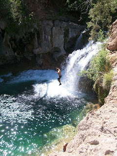
I can't get enough of this place. Fossil Creek is just so beautiful and the water is so perfect that you just want to keep going back. So yesterday I had a day off so I took my child and her friend back for another great day in paradise.
Since I could not get enough I thought maybe you might not of had enough yet as well. So i took a few more pictures to share of this amazing place. This one is at the falls that I posted the other day but from above. As you can see you can climb around to the top of the falls and many people jump into the deep pool from the cliff 30 or so feet above the water. The fall is at least 20 feet in height, so I'm guessing the cliff is at least 30 feet or more.
The stream has great waterfalls but also nice lazy and deep pools to relax in. There is also some "white water" or rapids type areas. I guess some people have gone down this river in kayaks, and even gone down the falls.
Anyway I feel pretty blessed to have this fantastic place within driving distance, so I can take a day trip over there and enjoy the water.
Oh The Water. . Ooohhh The Water. . And It Stoned Me To My Soul
Here is the link to the other Fossil Creek Post in case you missed it
http://azjonesoutdoor.blogspot.com/2011/06/fossil-creek-arizona.html
And here are a few maps that might be of value.
And here are a few maps that might be of value.
Anyway if you want to go here DON'T. . . . because I want it ALL to myself! Like that could ever happen. Anyway for more information contact:
Mogollon Rim Ranger District, 8738 Ranger Road, Happy Jack AZ 86024, (928) 477-2255 FAX 527-8282
or
Verde Ranger District, 928-567-4121 or
Red Rock Ranger District, P.O. Box 20249, Sedona AZ 86341, (928) 282-4119
Permits are now required to access fossil Creek. You need to get them in advance online. They are often booked well in advance.
https://www.recreation.gov/wildernessAreaDetails.do?contractCode=NRSO&parkId=74997
Permits are now required to access fossil Creek. You need to get them in advance online. They are often booked well in advance.
https://www.recreation.gov/wildernessAreaDetails.do?contractCode=NRSO&parkId=74997


great posts, thanks. which area (on the map) should you stop at in order to access the cliff jumping area you showed above?
ReplyDeleteLindsey, the trail head has a sign that says "waterfall trail" It is near where the trail head on the map is called "flume trail". It is about a mile hike one way. Be sure to check for access with the forest service. Right now all access is limited due to fire hazard conditions (all roads closed). Also before that the access road down from Strawberry had been closed due to a rock slide blocking the road, so the only was in was from the Camp Verde direction.
ReplyDeletegreat website!!
ReplyDelete