Grand Staircase Escalante-National Monument is a huge (1.9 million acres) and vast undeveloped and wild area in southern Utah and it has very few roads. In the western part of the national monument is a dirt road that runs north to south called Cottonwood Wash Road. It is a rugged dirt road that is impassable in wet conditions and it sees light traffic. This road runs along the "Cockscomb" also known as the East Kaibab Monocline. This is a fold in the rock layers tilting them up at 45 degree angles in spots and forming a long ridge of strange rock formations due to the differential erosion of these layers of rock.
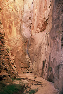
Along Cottonwood Wash Road is a short but sweet canyon hike that passes through the narrows of Cottonwood Wash. It is a very strange narrow canyon where a wash cuts into and through a large Navajo Sandstone ridge instead of just running along it and it comes out on the same side it entered.
This canyon part of the hike is really only about a mile and a half, but it is an interesting mile and a half. There is a bridge on Cottonwood Wash Road at the starting point of the north end of the hike. From there you scramble down into the drainage west of the road and head downstream. Almost immediately you enter in between some large rocks and are in a narrow canyon between two large cliffs. Right at this point you will see a canyon coming in from your right or north called Butler Valley Draw.
You can go up Bultler Valley Draw and there are about 200 yards of narrow canyon to see, and then return back down the way you came back into Cottonwood Wash. From there head south and you will be walking along a wash bottom between some large cliffs for about a mile and a half as it winds it's was in a generally southward direction. Early on the canyon will get pretty narrow and tight with tall cliff closing in on both sides. The last time I was there there was an old log jambed in between the two cliffs at one spot.
For me this is the most interesting part of the hike due to the cliff walls and rocks that are polished and smoothed from years of flash floods being forced through this small narrow slot.
The narrows will open up a little way farther downstream and you will be walking on a sandy wash bottom between two very large cliffs that I estimate could be 200 feet high or more in places. Along this section there are a few interesting short side canyons with towering cliffs that dead end into the bottom of what appear to be dry waterfalls. Note the backpack I left on the ground to give some perspective as to the size of the cliffs.
At one point you will hit a place where a landslide has blocked the wash but it is easy to scramble over. There are some places where the canyon opens up and the walls are not as dramatic but even that stretch has som beauty because you can then see the unusual rock formations on the top of the Navajo Sandstone cliffs that have been sculptured over time.
After about only a mile and a half the canyon will take an abrupt left turn and emerge out from the narrows into a wide valley. The road will be right there and you just hike north about a mile along the road to get to your car. The walk along the road is scenic as well with some interesting geology to see. The whole hike can take less than 2 hours and some people do it in less. Overall it is pretty short and mostly easy and could be a good hike for a family with kids. And it is well worth the effort considering the beauty and the interesting geology.
To get there you take Cottonwood Wash Road about 25.5 miles north from Highway 89 or if coming down from the north it is about 12 miles south on Cottonwood Wash Road past Kodacrome Basin. Elevation is at 5600 feet. Note that Cottonwood Wash Road is impassable in wet weather, so get a good weather report so you don't get your car stuck in the mud in this remote area. Carry plenty of water and food in your car.
Here is a link to another adventure that can be found along Cottonwood Wash Road.
http://azjonesoutdoor.blogspot.com/2010/10/yellow-rock-and-hackberry-canyon-utah.html


It's a beautiful place a lot of fabulous views.
ReplyDeleteUtah Mountain Bike