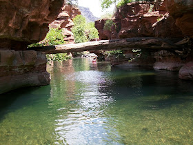
I just took a three day two night trip into Clear Creek Wilderness in Arizona, with my friend Cliff. It is one of my favorite spots. Its a deep remote canyon with a nice stream. And very few people willing to do the hard work it takes to get to the best parts.


The going is difficult because there is no trail. In places you must swim to go up the canyon because there are cliffs coming right out of the water. That is what makes it so special and what eliminates the crowds.
I have been in the canyon many times but it never gets old. My favorite spot to camp is at a water fall. Its about a 20 foot fall with a nice pool at the bottom. I feel its the best swimming hole in Arizona. We entered from a trail head found off forest service road 214. This trail is trail # 17 and it drops down into the canyon descending over 1700 ft. in only around two steep and rocky miles. You could take trail # 17 up from Bull Pen Ranch and avoid the steep rocky stuff but that's 5 to 6 miles. As you get near the bottom there is a trail leading east that is easy to miss. This takes you upstream to the narrow part of the canyon. Getting wet is mandatory for getting to the falls because one place the swim is a good 30 yards. And there are several other shorter swims. So you have to pack your stuff in "dry bags" and find a way to float your pack as you swim. Because of the narrow parts of the canyon this should be avoided in the monsoon season due to flash flood danger. Up to the left on this site where it says pages you will find a link to a map.


Hey AZ lets get out and bike in Flagstaff
ReplyDelete