..........................................................Arizona Jones Outdoors: Hiking, Backpacking, Mountain Biking, and more!

Showing posts with label Mountain Biking. Show all posts

Tuesday, September 6, 2011

Mountain Bike Gooseberry Mesa, Utah

One of the great mountain bike destinations of sourthern Utah is a place called Gooseberry Mesa. Gooseberry mesa ia a table top mesa located southwest of Zion National Park. It has a well defined trail system that was invented by and for mountain bikers. Gooseberry mesa has a mix of slickrock and single track trails in a pinion and juniper forest enviroment.
The mesa has large patches of exposed sandstone, that is white, gray, and some pink in color. Some areas are large flat and smooth and some are more divided lumps that you have to go over and around to navigate the trail. The trails are pretty easy to stay on for the most part because someone has painted dots on the stone to keep you on the right path.  One notable area is called "Gods Skateboard Park" where there is some large sections of flact rock and plenty of areas to freelance off the marked trails.
Here is a little video of my brother in law, my nephew, and myself to give you an idea of what it looks like.
Some of the trail has some technical sections. But in most cases I found it to be very rideable, but if you have problems just walk the tuff parts. The trail takes you out to the south edge of the mesa where you can see across a valley over to Little Creek Mesa another great mountain bike desination, that I covered already in this blog http://arizjones.blogspot.com/2010/07/mountain-bike-adventures-in-utah.html
Once you get to the rim the trail heads west along the rim and leads you out to a narrow exposed place called "The Point". At The Point you will have unblocked view in all directions.
Here is a picture of me riding along the rim near The Point. It's a long way down from here to be sure.
If you head back down the dirt road you can catch a trail thet then takes you northeast along the northwest rim of the mesa. This section has some great views as well.
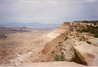
This section might be my favorite due to the great views.  It is just one amazing spot after another, over looking the Virgin River Valley, with the massive cliffs of the Zion region in the background. 
Honestly photos just can't capture the way thsi looks because it is just so big and vast of a panorama. 
As you can see in some places you are just right on the edge of this huge cliff that drops of what seems like thousands of feet.  And the scenery is enough to distract you so be careful. 
Here is a trail map that can be handy. I have always gone out on the South Rim Trail and then come back on the North Rim Trail (used to be called "That Dam Trail") and then go out on what used to be called Steves Rim Job. Since I have often camped I would also ride around on the Slick Rock 101 and the Bowls and Ledges and then link that with the Hidden trail for a second ride.
From Springdale - drive 4 miles west on UT-9 to the east end of Rockville turning left on Bridge Road. This can be easy to pass so keep your eyes open. Go 1.6 miles, crossing over the Virgin River, the turning left at a T-intersection onto the Smithsonian Butte Scenic Backway. Follow maintained dirt road 4.9 miles turning right on Gooseberry Mesa Road. Sections of this road can be very very rough. After 3.6 miles, turn left onto an unsigned double track and go 1 mile to the trailhead at a cattle gate.

From St. George, drive north about 7 miles on I-15 then go east on UT-9 to Hurricane, UT. In Hurricane, turn right on UT-59 heading west for 14.4 miles. Look for Smithsonian Butte Scenic Backway signs, you'll make a left onto a maintained dirt road. This is an unmarked road located between mile markers 8 and 9. Head north 2.9 miles then left at the fence signed Gooseberry Mesa Road. Drive 3.6 miles on dirt road taking a left onto an unsigned double track and go 1 mile to the trailhead at a cattle gate.

Here is a link to my Little Creek Mesa page.  It is just across the valley south of Gooseberry Mesa. 
http://azjonesoutdoor.blogspot.com/2010/07/mountain-bike-adventures-in-utah-little.html

Monday, September 5, 2011

Mountain Biking, Red Canyon, Utah


One of my favorite mountain biking destinations that I have been to is Red Canyon, in southern Utah. This place has great scenery and nice trails. The scenery is a lot like Bryce Canyon but they let you ride a mountain bike through it.


Here is a little video of my brother in law, nephew, and me at some places along the Thunder Mountain trail.


It has around 34 miles of single track and there are some jeep trail opportunities near by that are not in the park. There is also a paved bike trail along the highway that makes for safe transit to trail heads.

The trails are very well maintained and go through a wonderland of red rock formations. The Thunder Mountain trail alone is worth the trip.

One of the best things about Red Canyon is the campgrounds with hot showers. It is pretty sweet to be able to ride right out of camp to fantastic trails and then end back at you camp and get a nice shower. This is a must do if you love mountain biking and are in southern Utah in the summer.

Here are the trails.
Losee Canyon Trail: This 2.9 mile moderate trail begins at the bottom of Losee Canyon off Castro Canyon Road. This trail heads east and connects with the middle section of the Cassidy trail.
Cassidy Trail: This 8.9 mile strenuous trail is named for the infamous Butch Cassidy, who used sections of the trail. This is an out and back. so if you go out and back it's almost 18 miles.
Thunder Mountain Trail: This is a 7.8 mile moderate to strenuous trail. The red rocks on the lower section of the trail are outstanding. This can be a strenuous out and back totaling 15.5 miles. Or you can do a loop by riding up the highway to the top of the mountain and then down Thunder Mountain Trail. This loop is around 15 to 16 miles but is much easier. And I think you gain at least 1000 ft elevation if not more. The decent on Thunder Mountain is real "Big" fun!
Casto Canyon Trail: This 5.5 mile trail offers spectacular scenery. And runs east from Castro Canyon Road and links up with the upper northern end of Cassidy trail
You could also do some epic loops by linking Cassidy and Castro Canyon or Losee Canyon.
There are also ATV trails off Tom Best Road and some others.

The elevations in this area are between 7000 and 8500. So this is a summer destination
Red Canyon Camping
The Red Canyon Campground is shaded by ponderosa pines, junipers and Douglas firs. The 35 site campground usually closes the first day of October and opens again May first. The charge for camping is $11 per day. There are tables, grills, group sites, flush toilets, showers and a few RV pull throughs.
Directions to Red CanyonFrom Salt Lake City travel south on Interstate 15 past Beaver to UT 20. Exit on UT 20. Turn south on UT 89 and travel past Panguitch. Follow UT 89 to UT 12. Travel along UT 12 to Red Canyon.
From Las Vegas: Travel Interstate 15 past St. George to Exit 16. Drive through Hurricane, Utah. Follow Hwy 9 through Hurricane and to the only stop light in LaVerkin. Turn right at the stop light. Continue on Hwy 9 to the south entrance of Zion Park. Drive through Zion to the junction of UT 9 and UT 89 at Mt. Carmel Jct. Turn north on UT 89, then exit on UT 12. Follow UT 12 to Red Canyon.
Red canyon is just a bit west of Bryce Canyon on UT 12.
Here is a link to a trail map Of Red Canyon
http://arizjones.blogspot.com/p/red-canyon-map.html

Tuesday, June 21, 2011

Mountain Biking Mount Elden, Flagstaff AZ

   Well anyone that knows me, "Arizona Jones", knows that I like to mountain bike.  In the summer it can get pretty hot in Cottonwood where I live.  In fact temperatures of well over 100 degrees are nothing unusual.  So when it gets hot I like to travel to higher elevation where it is cooler to ride.  One of those spots is Mount Elden near Flagstaff Arizona.  Mount Elden is part of a series of mountains north of Flagstaff called the San Francisco Peaks volcanic field.
 Mount Elden is one of the  peripheral mountains and it rises up above the already 7000 foot high plateau that Flagstaff is on.  Mount Elden is one of the farthest south of these mountains and is also one of the smaller ones being about 9297 feet in elevation.  Some of the other peaks reach as high as 12,000 feet. 
   Most of the other mountains are in a designated wilderness area but Mount Elden is not and so Mountain Bikes are allowed.  On Mount Elden is a great trail system that gives you opportunity for many different loop or out and back options.  With the bottom of the mountain being a full 2000 feet below the summit there are also great opportunities to get in some fun downhill runs as well as the tough climbs for those who want a serious workout.  And serious climbs at this altitude will really test even the best mountain bike riders. 
  
But for me it is about not just the workout but the enjoyment and the beauty.  Mount Elden is covered with a beautiful forest with a variety of trees including Ponderosa Pine, Douglas Fir, and Aspens. The eastern slopes of Elden were badly burnt by the Schultz Fire in June of 2010 but much of the good stuff is still intact. So here are some trail descriptions, to help plan a ride or hike.
Oldham Trail #1
Mt. Elden's longest trail at 5.5 miles, it begins at the north end of Buffalo Park (elev. 7,000 feet) in Flagstaff and climbs gradually past boulder fields and cliffs on the west side of Mt. Elden. You cross Elden Lookout Road several times as the trail winds higher through forest and meadows to Oldham Park and on to Sunset Trail near the summit. The trail is moderate at the bottom but gets very difficult on the upper part if you are climbing and has an elevation gain of 2,000 feet.
Rocky Ridge Trail #153
Ponderosa pine, Gambel oak, alligator juniper, cliffrose, and yucca line this western approach to Mt. Elden. This trail begins from Schultz Creek Trailhead heads east and connects with the Oldham and Brookbank Trails. Distance is 2.2 or 3 miles depending on which fork you take. Schultz Creek Trailhead lies a short way off Schultz Pass Road 0.8 mile in from US 180. Elevation change is only about 100 feet but there are some rocky technical parts on this trail.
Brookbank Trail #2
This moderate to steep 2.5-mile trail climbs north through a forested drainage to the edge of Brookbank Meadow, owned by the Navajo Tribe, then curves east to eventually meet Sunset Trail at a low saddle. The part of the trail between Brookbank Meadow and the Sunset Trail goes through some very nice forests and meadows.  Elevation gain is 1,000 feet. The trailhead (elev. 7,900 feet) can be reached by hiking or biking the Rocky Ridge or Oldham Trails or by driving a half mile in on Schultz Pass Road from US 180, then turning 2.5 miles up Elden Lookout Road.
When at Brookbank Meadows in the Dry Lake Hills area I often take an unnamed trail out southwest across the meadows to a view point that over looks parts of Flagstaff. There is a rock outcrop that I often take a break at and enjoy the view.
Schultz Creek Trail #152
This gentle 3.5-mile trail parallels an intermittent creek and also paralles Schultz Pass Road. The top is at Shultz Pass at the Sunset Trail Head (elev. 8,000 feet) and the bottom at Schultz Creek Trailhead (elev. 7,200 feet). Sunset Trailhead is at Schultz Pass, 5.6 miles up Schultz Pass Road from US 180, and Schultz Creek Trailhead is a short way off Schultz Pass Road 0.8 mile in from US 180. This is a very fun and fast downhill!
Sunset Trail #23
The alpine meadows and forests on the north side of Mount Elden offer some of the most pleasant hiking and bikling in Arizona. The four-mile Sunset Trail climbs gradually from Schultz Pass through pine, fir, and aspen to Sunset Park and on to the summit; elevation gain is 1,300 feet.  as you climb away from Schultz Pass you have some nice views back towards the San Francisco Peaks.  Latter as your head south you will traverse along the eastern edge of Mount Elden and will see below the visible scars left by the Radio Fire of 1977, and more recently the damage left from the Schultz Fire.  from different points on the Sunset trail you can view the San Francisco Peaks, Sunset Crater, and Painted Desert.
Begin from the Sunset Trailhead (elev. 8,000 feet), just west of Schultz Tank at Schultz Pass. To reach the trailhead, follow US 180 northwest three miles from downtown Flagstaff to Schultz Pass Road, then turn right 5.6 miles.

Little Bear Trail #112
This trail is steep in places with some switchbacks is 3.5 miles long with a 1,000-foot elevation change between Little Elden Trail and Sunset Trail. This may be still closed due to the big Shultz Fire in June of 2010.  This area being burned is a sad loss.  It was a real fun and beautiful trail to ride. 

Little Elden Trail #69
This trail descends down to the east side of Shultz Pass from Schultz Tank and links to trails that wind around the base of Mount Elden. From Schultz Tank to the bottom of Heart Trail in 4.7 miles. I have not tried this area since the Shultz Fire but I'm pretty sure this area has significant damaged.

Here is a trail map I came up with to help navigate.  There are also many trails that are not named that are north of Schultz Pass Road that can be explored.  As well as several on Elden itself. 

My earlier post about the Shultz Fire  http://azjonesoutdoor.blogspot.com/2010/07/fire-on-mountain.html  

Here is the best map I have found for the Mt. Elden trails by Dale Wiggins. It has many on it I have not been on. Very detailed!
http://singletrack.us/gallery/displayimage.php?album=58&pos=0

Tuesday, May 3, 2011

Exploring the Mogollon Rim Country of Arizona

I just got back from three days in an area of Arizona called the Rim Country.  This area is called that due to the predominant geological feature called the Mogollon Rim.  This "rim"is a long cliff like uplift running east to west for close to 200 miles.  It is essentially the southwest edge of the Colorado Plateau.  The south edge of the rim rises to heights over 7000 feet in elevation with some points reaching as much as 8000.  Below the rim are areas of around 5000 to 6000 foot elevation sloping away south gradually.  This area, both above and below the rim, is part of a huge forest of pine trees that comprises the largest stand of Ponderosa pines in the world. 
This stand of pine forest covers tens of thousands of acres from west of Flagstaff in the west all the way into New Mexico in the east. 
Most people when thinking of Arizona think of desert, but much of Arizona is covered with this vast pine forest.  This high area, due to it's altitude has significant snow fall in winter and because of this is a source of many streams that run south and north away from the rim.  This along with the cooler temperatures due to altitude make this a favorite area to escape the heat of the deserts in the summer months. 
   When I went there I stayed in a small town below the rim called Christopher Creek.  Christopher Creek is at about 6000 foot elevation surrounded by dense forest with a year round stream running through the small town. 
There are many hiking and mountain biking opportunities there in every direction with campgrounds as well as undeveloped camping opportunities.  The stream called Christopher Creek starts at the base of the rim at a place called See Canyon where there is a nice trail that runs along the creek through the forest.  Downstream from the small town the creek enters an entrenched canyon called The Box. .
The Box is hard to navigate and has small falls and pour offs with deep pools and requires getting wet and some climbing skills to navigate up and down the canyon. 
The canyon rock is comprised of block shaped basalt rock. 
   Up on the rim north and east of Christopher Creek are five small lakes nestled among the pine forests,  called the Rim Lakes. 
The rim lakes are in depressions on the rim and collect snow melt during the winter. These lakes are stocked with trout and are packed with fishermen during the summer months. 
Along the rim is a dirt and gravel road called the Rim Road or The General Cook Trail that follows the edge of the rim for close to 40 miles.  Along this road are great views of the vast forested areas below the rim.
The rim area has many wonderful places to camp, both developed campsites and just dispersion camping with no facilities.  The forest on the rim being higher is more lush and diversified having some spruce and aspen trees as well as the ponderosa pine. Elk, deer, and wild turkey are often seen in these forests.  Below the rim as I said are a series of streams and creeks that flow south,  Some big and some small. 
We explored Haigler Creek, Christopher Creek, Tonto Creek and the East Fork of The Verde River.  The East Fork of the Verde appeared to have the largest amount of water flow, and some great places but also appeared to have some of the most development.  Yet even with this there were plenty of opportunities to get away from the crowds, this early in the year.
 There are many hiking and mountain biking trails in this vast area with the most notable trail being the Highline Trail. 
The Highline trail runs for more than 50 miles along the base of the rim through dense forest and rolls up and down as it descends and climbs out of the many stream drainages it crosses.  In many places it can be mountain biked as well as hiked.  I have ridden the east end and some of the connecting trails and found it to be some real nice riding.
   This time, when we went, instead of camping we stayed at the Christopher Creek Lodge.  This lodge, founded in 1950 is a group of small rustic cabins along the creek.  http://christophercreeklodge.com/
I found it to be a great base camp for exploring and loved the creek side location and the feel of the place.  No frills but all you need with wood stoves, and a kitchen and a great location with the sounds of the creek to put you to sleep at night.

Thursday, March 17, 2011

Mountain biking at Dead Horse State Park, AZ

Most of you know I live in a town called Cottonwood, AZ in the Verde Valley just south of Sedona. Cottonwood is overlooked by most visitors to the Verde Valley who come to see Sedona and the old mining town Jerome. But Cottonwood has some cool stuff too. In Cottonwood is a place called Dead Horse State Park that has a trail system to hike and mountain bike on. The park is located along the Verde River the only designated wild and scenic river in Arizona. Normally I park outside of the park to avoid the entrance fees and then just ride in on trails by turning right down a steep slope just after I cross the bridge or I go past the entrance station about 50 yards and enter on a trail to the right.
Once in the park there are tons of trails that wind all around connecting the different camp grounds and fishing lagoons. Some of the trails parallel the river among the large cottonwood and elm trees.
And some cruise and wind through the beautiful mesquite groves that are closer to the river and many travel through the desert areas farther away from the river.
Most of these trails are very smooth and easy with a few short steep climbs and in some cases a few small foot bridges to cross small washes
Now all these trails are nice but the real attraction for me is the trail system that leaves the park and climbs the mesas north and east of the park. There are two main trails that head up the mesas. One is called Lime Kiln Trail and it is heads east out of the park and the other one is called Raptor Hill at it generally heads north out of the park.
Both of these trails climb in stair step like increments of short steep climbs with flat smooth areas between climbs. The state park near the river is around 3280 feet in elevation and on Raptor Hill trail you will be at around 3900 when you get to the trail junction with the Thumper Trail after traveling 2.85 miles. Thumper Trail runs southeast from Raptor Hill Trail and connects with the Lime Kiln trail completing a loop. If you are traveling east on Lime Kiln Trail you will reach the Intersection with Thumper Trail after about 2.1 miles. It is 2.25 miles to get from one end of Thumper to the other making the entire loop about 7.2 miles of trail. Add in the time on the trails in the park and you will be doing at least 8 miles to do the loop. Thumper Trail gains and looses elevation several times as it goes in and out of a series of washes. At the Raptor Hill and Thumper intersection there is also a trail that heads off to your left or north this can take you to several longer options. The most noted is the Upper Raptor Hill Trail that was once called Indian Chimney but the name was changed by the State Park people. Upper Raptor can be easy to miss, it is on the right a few hundred yards north down a double track from the Raptor/Thumper junction. Upper Raptor starts by going up a small wash and then climbs up out of the wash to the right. Upper Raptor continues your climb to the top of the mesas and connects to a series of Forest Service roads. The top of the mesas reach an altitude of at least 4300 feet and maybe even more. The top of the Mesa has juniper and pinion pine. Along the steep northeast edge of the mesa are nice views of the Red Rock country. This trail system is great in winter, spring, and fall, but can get hot in the Summer. I often take a break here to enjoy the view and then return the way I came with a long downhill to end the day. By adding some of the forest service roads you can make loops as long as 20 or more miles. And for the very hardy you can take Lime Kiln Trail all the way to Sedona a long trek of at least 15 miles one way. There are two bike shops in Cottonwood If you need repairs or forgot something when you visit.
They are both located on main street not far from the park. One is called Sultana Cycles and is located at 470 S. Main, Suite B. Cottonwood, AZ. (928) 649-3822, Sultanacycles@gmal.com The other one is called Zoomers Bike and Gear and it is located at 743 N. Main Street, Cottonwood, AZ. (928) 202-4941, http://www.zoomersbike.com/ To get to Dead Horse State Park, from I-17 take (exit 287) Hwy 260 to Cottonwood. Hwy. 260 intersects with 89A/Main Street. Turn left on Main Street and proceed to North 10th Street. Turn right (north) on North 10th Street. Continue on North 10th across the Verde River Bridge to the park entrance. The Park also has camping, fishing, hiking, horseback rides, among other things.

Wednesday, January 26, 2011

Black Canyon Trail, AZ, Hike and Mountain Bike

I live in a beautiful valley in Central Arizona, called the Verde Valley. The Verde Valley has the Sedona area that people come to see from all over the world. But in my area there are many other things that often get over looked. I live in the town of Cottonwood it is south of Sedona and just south of me is a mountain ridge that reaches heights of over 8000 ft. elevation. On the side of this mountain ridge is a trail that climbs up a drainage called Black Canyon. This trail is designated by the Forest service as Black Canyon Trail #114. Most people just hike up and down the trail and many people descend the trail on mountain bikes, but few go off trail and see the hidden secret. Down hidden in the drainage of Black Canyon is a beautiful waterfall. Being in the desert southwest I think it usually only runs in the winter when there is snow on the top of the mountain. This waterfall is a bit difficult to get to so it keeps the masses away. It is pretty much an all day in and out hike, with some steep climbs and some off trail scrambling, but the hike has many rewards, like great views of the Verde Valley and seclusion from all the tourists that swarm the Sedona trails. This area is wild and has deer, elk, mountain lions, bear, and lots of javalinas.
You start the hike at a parking area at the end of Ogden Ranch Road. If there is any snow on the mountains then the waterfall will be flowing. The trailhead elevation is around 4200 feet. From there you take a ATV track west for about 50 yards and then look for a trail leading down into a drainage on your left. Take this trail and it will take you down into the drainage and across and then starts to climb the other side.
This trail will get somewhat steep and rocky at times as it navigates up and over or around a few ridge lines and drainages to take you southwest and into the Black Canyon drainage. Along here you will have some fine views of the Verde Valley.
Once you turn the corner into the Black Canyon drainage the trail will level out as it traverses the south side of a ridge. This is what the drainage looks like that you will be heading into as seen from the trail above.
Along this area of trail you look for a ridge below you that sticks out south into the drainage with a saddle on it with a fire ring made of rocks. At this point you go off trail down to the saddle and then drop down the steep ridge on the west side of the saddle to find your way down into the bottom of the drainage. You will see a small drainage coming in from the north to the major one. You need to cross this above the intersection of the two drainages. This is a photo of the side drainage that comes in from the north
You cannot cross below the intersection because the drainages drop off into a slot that cannot be crossed. Once past this side drainage you then follow the main drainage upstream. It is a bit of a scramble.
If there is water flowing then the waterfall will be flowing too. You have to find your way around several small cascades and some rock pinnacles along the way that I found to be interesting.
Finally the drainage will turn to the right around a corner and the water fall will come into view. It is a pretty tall waterfall but I'm not very good at guessing heights (maybe 70 feet tall?) Many people also mountain bike down this trail. If you are going to do that you would need a car shuttle. Many people start at the top of the mountain and decent Coleman Trail or Gaddes Canyon Trail and then hook up with Black Canyon Trail as it drops off of Allen Springs Road (FR 413) at 6400 ft. elevation. The top part of the Black Canyon trail is in pine forest and runs along a small stream for part of the way. It it is a total of 7 miles from the bottom at Ogden Ranch road up to the top at Allen Springs Road. The bottom part of the trail is high desert type vegetation and there is more than a 2000 foot elevation climb along this trail.
If you are going to try the downhill mountain bike ride I would suggest you take the Gaddes Canyon Trail over the Coleman Trail. The Coleman trail is for hard core technical riders only. All of this is for advanced riders but Coleman is really very rocky, steep, and overgrown. Gaddes Canyon Trail is around a 2.5 mile drop down to Allen Springs Road. If you combine that with Black Canyon you have close to a 10 mile downhill trip. The Gaddes canyon Trail starts at around 7700 ft elevation so you will descend close to 3500 feet on this downhill trip. When you go down Gaddes Canyon and reach the Allen Springs Road (FR 413) you head left or east on Allen Springs road and the Black Canyon Trail will be on the right after more than a mile. Beware that the brush is overgrown in many places on these trails and you will need protection to not end up all cut and scratched up.
To get to the trail heads: For the bottom trailhead of Black Canyon Trail #114, turn off Highway 260 between mileposts 209 – 210 (south) onto the dirt Ogdon Ranch Road (ok for passenger cars). Follow this road 4.3 miles to the parking lot at the end.
To get to the Gaddes Canyon Trail, from highway 89A you take Forest Service road 104 around 2 and 1/4 miles to road 104B. Turn right and the trail will be on your left just a tenth of a mile before you reach the lookout.